Leave the Phoenix area early, follow Horton Creek into the forest, then head back to Payson for Duza’s Kitchen around noon.
The spring is the wish-list finish. The five-mile creek walk makes a gentler morning. Choose together before leaving the trailhead.
November escape · Choose your hiking distance
Choose your morning
How far for the spring?
The route endpoint matters: Travelness’s 8.6-mile plotted route extends north beyond OpenStreetMap’s Horton Spring point. See the coordinate comparison below before treating the full route as the distance needed to reach the spring.
The five-mile creek walkHorton Creek · Arizona
01 / Keep it social
The five-mile creek walk
For a five-mile outing, follow the mapped creek trail for 2.5 miles from your parked car at Derrick Trailhead, then retrace your steps. Track distance as you walk. This is a chosen distance limit, not a measured route to Horton Spring; reaching the spring is not part of this option.
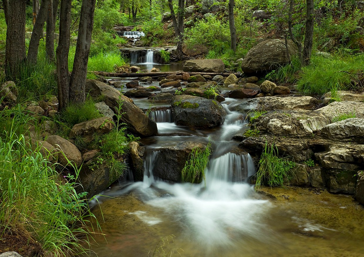
Horton Spring · flow and greenery vary with the season.
02 / 🌟 Recommended · 7-mile jog/hike
Horton Spring
This is what we’re walking for: little cascades threading between mossy rocks, clear pools and green woodland along the creek. Our recommended seven-mile jog/hike scenario includes about 1,300 feet of estimated elevation gain and 20 minutes total for water, a snack and photos before heading back for lunch.
Follow Horton Creek toward Horton Spring and return the same way. Travelness publishes 8.6 miles, but its plotted track continues beyond OpenStreetMap’s spring marker. Along that track, the closest point to the mapped spring is about 3.43 miles from the route start, roughly 155 feet from the marker. Doubling that segment gives 6.85 miles before the unverified spring approach and parking connection. The roughly 1,300-foot gain is a terrain-model estimate for the measured out-and-back near the spring. The final approach and parking connection are not fully captured. This is coordinate evidence, not a verified car-to-spring route. Park at Derrick Trailhead for this plan and allow about five minutes each way to Horton Creek Trailhead.
The loop combines Horton Creek, Highline and Derrick. Travelness describes a 9+ mile version; that may differ from the linked AllTrails route. Review the exact track and spring approach before using a loop distance or comparing it with the out-and-back.
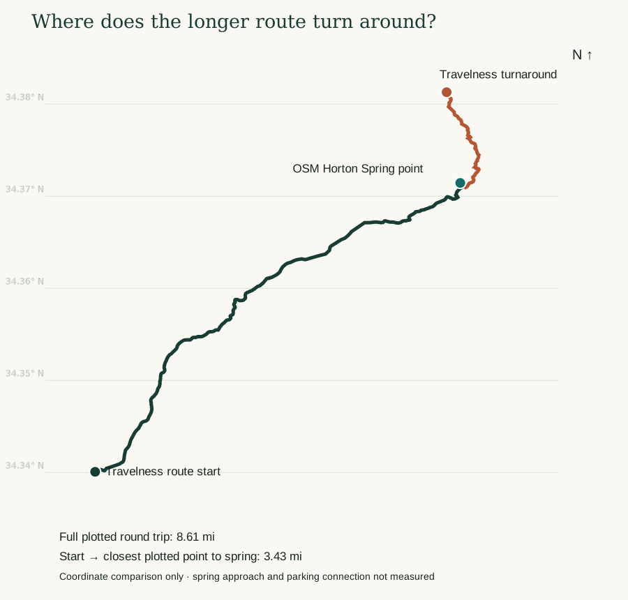
Travelness’s full plotted route measures 8.61 miles, but its turnaround is beyond the OSM spring marker. Neither that total nor the shorter measured segment establishes the exact Derrick-parking-to-spring distance. No shortest-route claim is made.
See the route
Horton Creek, on the map.
The Google My Maps route embedded by Travelness. Zoom in to inspect the mapped line and endpoints before choosing your hike.
Why route distances differ · inspect the coordinate evidenceCoordinate evidence: green follows the Travelness track to its closest point to the OSM spring marker; rust continues to the guide’s turnaround. The dashed connection is proximity only, not a verified walking path.
Why the distances differ: the complete Google map line measures 8.61 miles by summing distances between its coordinates. Its start is 34.34007, −111.09545; its turnaround is 34.38129, −111.06091. OpenStreetMap places Horton Spring at 34.3714407, −111.0595692, south of that turnaround. The track passes within about 155 feet of this marker after 3.43 miles, then continues about 0.88 mile each way. This suggests extra travel beyond the spring vicinity; it does not verify the last approach or which spring feature hikers use.
Map credit: the map embedded in the Travelness guide, hosted on Google My Maps. It is an online route reference, not a downloaded offline navigation file. Save an offline trail map before leaving service.
Understand the climb
Creek climb, then a steeper finish.
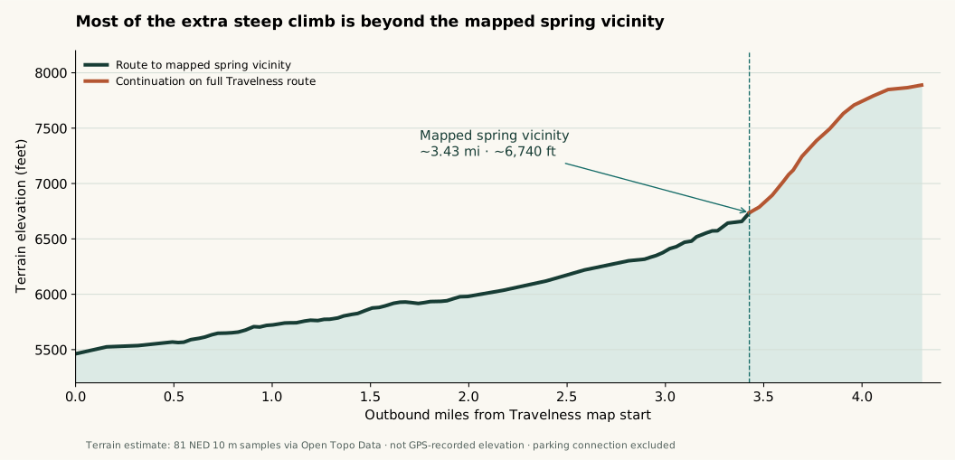
Estimated terrain elevations sampled along the outbound Google map track, using NED 10 m terrain via Open Topo Data. The return retraces the profile. This is a terrain model, not recorded GPS elevation; small ups and downs and the parking connection are not captured fully.
When would we get near the spring? The measured 3.43-mile outbound segment takes about 1 hr 09 min at 20 min/mile, or 1 hr 43 min at 30 min/mile. Add five minutes from parking and ten minutes of pauses: leaving the car at 8:20 puts you near the mapped spring around 9:44 am or 10:18 am, respectively. Reaching the water may take longer because the final approach has not been measured.
Start → spring vicinity
~1,280 ft
Net climb over ~3.43 miles
Roughly 5,460 to 6,740 feet. About 7% average uphill grade. Expect the outbound miles to take more effort than the downhill return; use a comfortable hiking pace on the climbs.
Beyond spring vicinity
~1,150 ft
More climb in ~0.88 mile
The full mapped route continues to roughly 7,890 feet. Its net rise is about 25% of horizontal distance over this segment. This continuation is much steeper; a 20-minute mile here may be unrealistic.
Pace planning
20 / 30 min
Use an overall average
Jog/hike at 20 min/mile assumes hiking uphill and jogging easier sections. Slow hiking at 30 min/mile is a gentler moving average. Breaks are additional. Adjust at the first mile based on the group’s actual pace.
Pace × distance + breaks
Put lunch on the clock.
These are planning calculations, not predicted hiking speeds. Pace is moving pace averaged over the whole route; stops are added separately. Plan to leave the trailhead by 11:00 am, allowing about 40 minutes to Payson and 20 minutes for parking and delays.
Moving time + 20 minutes total for breaks
Outing
Jog/hike · 20 min/mile
Slow hike · 30 min/mile
5 miles total from parking
1 hr 40 moving 2 hr total
2 hr 30 moving 2 hr 50 total
~7 miles · ~1,300 ft gain Provisional spring scenario
🌟 Recommended base2 hr 20 moving2 hr 40 total
3 hr 30 moving 3 hr 50 total
Full 8.6-mile map route Includes 10 min extra for parking connection
2 hr 52 moving 3 hr 22 total
4 hr 18 moving 4 hr 48 total
9-mile planning buffer Includes 10 min extra for parking connection
3 hr moving 3 hr 30 total
4 hr 30 moving 5 hr total
All options include 20 minutes total stopped time, such as ten minutes at the spring and two five-minute pauses. Take longer if the group needs it; extra stops add time to the plan. Five and seven miles are car-to-car distance budgets including the parking connection. Seven miles and ~1,300 feet of gain remain estimates: the final spring approach and parking link have not been fully measured. The longer map routes reserve ten additional minutes for the connection, and the steep upper continuation makes a 20 min/mile average ambitious. Setup at the car is separate.
🌟 Recommended base · 7-mile jog/hike
One day, in order.
Leave the Phoenix area at 5:20 am, jog/hike at a moving average of 20 min/mile, and allow 20 minutes total for breaks. This seven-mile scenario has about 1,300 feet of estimated gain. Target an 11:00 return to the car, followed by lunch around noon. This schedule has no extra hiking buffer.
5:20 am
Leave Phoenix
Budget 2 hr 30 min driving and a 15-minute charging allowance. Aim for the Payson stop around 7:10–7:25 am, then continue to Derrick parking. Coffee and a restroom visit can overlap charging if service is quick; extra time comes from the morning buffer. Starting the Model Y at 100% may let you skip that charging stop if navigation confirms enough reserve. Your actual starting point and traffic determine the drive.
~7:10 am
Charge & coffee in Payson
Budget 15 minutes charging at the Payson Supercharger. The Starbucks by Bashas’ is about two minutes away on foot and lists a restroom. Coffee and bathroom time can overlap charging if the counter is open and service is quick; allow extra if needed. See the stop, walking map and hours ↓
8:05 am
Park at Derrick
Take 15 minutes to change shoes, organize water and get ready. The connection to Horton Creek Trailhead is included in the seven-mile car-to-car planning budget.
8:20 am
Jog/hike to the spring
Seven miles at 20 min/mile is 2 hr 20 moving. Add 20 minutes total for pauses, a snack and photos: 2 hr 40 elapsed. Hike the climbs and jog comfortable sections. This average and the seven-mile spring distance are planning assumptions, not promises.
11:00 am
Back at the car
Target finish for the base plan. Change shoes and head toward Payson promptly. There is no spare hiking buffer before the lunch drive; a longer spring approach, slower pace or extra stop shifts lunch later. Turn back early if the remaining route will exceed the window.
11:00–noon
Drive to Payson
Allow about 40 minutes driving to Duza’s Kitchen plus 20 minutes for parking, a possible wait and delays. Derrick Trailhead → Duza’s directions ↗. This is a planning allowance; check the actual route and traffic.
Noon
Lunch at Duza’s Kitchen
Block 60–75 minutes, through ordering, eating and paying. View Duza’s Kitchen ↗. Confirm current hours and kitchen cutoff; the provisional close is 2 pm. Macky’s Grill ↗ is the backup for a later lunch.
1:00–1:15 pm
Finish lunch & check charge
If Tesla navigation calls for a top-up, budget 15 minutes charging plus up to ten minutes for a queue or detour. This is separate from lunch; restaurant charging is not confirmed. Without a stop, head home after lunch. With it, expect to leave Payson around 1:15–1:40. Allow longer if navigation predicts more charging.
3:00–4:00 pm
Home in Phoenix
Allow roughly two hours driving from Payson to your Phoenix-area destination. A 1:00 departure puts you home around 3:00; a 2:00 departure around 4:00. These are provisional travel allowances, not live journey times.
Adjust from the base
A little longer, a little earlier.
Each adjustment below is measured against the 5:20 am / seven-mile jog/hike base. “Leave earlier/later” shifts the whole morning to preserve the same 11:00 am finish, keeping the lunch block unchanged. Driving, charging, setup and 20 minutes of breaks stay the same; longer map routes add ten minutes for the connection.
Choose one alternative · apply its departure adjustment
Alternative
Change in outing time
Leave home to finish at 11:00
5-mile jog/hike · 20 min/mile
−40 min
6:00 am · 40 min later
5-mile slow hike · 30 min/mile
+10 min
5:10 am · 10 min earlier
7-mile slow hike · 30 min/mile
+1 hr 10
4:10 am · 1 hr 10 earlier
Full 8.6-mile jog/hike · 20 min/mile
+42 min
4:38 am · 42 min earlier
Full 8.6-mile slow hike · 30 min/mile
+2 hr 08
3:12 am · 2 hr 08 earlier
9-mile buffer · jog/hike / slow hike
+50 min / +2 hr 20
4:30 am / 3:00 am
Keep the 5:20 departure instead? Add the outing-time change to the base finish. Seven miles at slow-hike pace would finish about 12:10 pm, so the same one-hour drive/arrival allowance puts lunch around 1:10 pm. Every extra ten minutes stopped adds ten minutes to the finish.
If parking slips to 9:00: take 15 minutes to get ready and leave the car at 9:15. With 20 minutes of breaks and an 11:00 return deadline, allow about 4.25 miles total at 20 min/mile or 2.8 miles at 30 min/mile. Turn by about 10:05 and retrace your steps; this becomes a shorter creek walk.
Tesla plan · coffee & comfort stop
Plug in. Grab a coffee.
15 minutes charging. The itinerary assumes a Model Y starting at 100%, with a 15-minute top-up allowance in Payson. Actual need comes from Tesla navigation, not a fixed promise. Precondition using the charging destination and follow the car’s predicted duration.
Payson Supercharger. Google Maps lists it at 142 AZ-260, Payson Village, open 24 hours. Enter the Supercharger itself in navigation. Check current stall availability in the car; station power and live availability were not independently verified.
Coffee + restroom nearby. The Starbucks at the same 142 AZ-260 address is about a 2-minute walk / 456 feet from the chargers according to Google Maps, whose café listing includes an accessible restroom. Bashas’ official page lists the host store at this address open 6 am–9 pm every day.
Morning plan: provisionally arrive in Payson around 7:10 am, charge until about 7:25 and continue toward Derrick Trailhead. Walk over for coffee or a restroom visit while the car charges if the counter is open and the queue is short. The 15-minute allowance is charging time; walking, ordering and restroom waits may extend the stop. Unplug and move the car when charging is done.
Hours check: Google lists this Starbucks opening at 6 am on the next weekday, but its Sunday counter hours were not confirmed. Bashas’ grocery hours are verified separately and do not guarantee café service. Call (928) 474-4495 before departure to confirm the counter and restroom will be available. The restroom is listed by Google, not guaranteed by the charger operator.
Map and amenity listings checked November 4, 2026. Starbucks listing and amenities ↗ · Tesla charging locations ↗. Resolve an alternative before departure if the car cannot verify a reachable charging stop. Do not rely on charging at the trailhead or restaurant.
Eat well
Keep the noon table.
Lunch is the anchor. The trail route should fit the group and the clock.
First choice · confirm before leaving
Duza’s Kitchen
Aim to arrive at 11:45 am–noon and block 60–75 minutes for lunch. Plan around a provisional 2 pm close; current hours still need confirmation. Confirm the chosen day’s opening hours and last kitchen order before committing to the early drive.
Allow about 2–2.5 hours driving each way from the Phoenix area, before stops; these are provisional allowances, not a checked live route. This plan uses Derrick Trailhead parking, then an approximately five-minute walk to Horton Creek Trailhead. Confirm current parking access before departure. The linked guide starts at Tonto Creek Campground, so check its map against the parking connection rather than assuming the published mileage begins at the car.
01 / Navigate
Confirm the trailhead
Navigate to Derrick Trailhead parking for this plan. Download the route before leaving service; do not navigate to the spring itself by car.
Verify Tonto National Forest trail and road access, fire restrictions, and the forecast for the trail elevation. Check conditions for your chosen November date before setting out.
Bring warm layers, headlamps for early starts, water, food, an offline map and shoes with grip. Wet leaves, rocks and possible ice can slow the walk. Carry drinking water; treat any creek water.
Make it your own
Choose a day. Check the details.
Choose a November day and adjust the departure time for your Phoenix-area starting point, traffic and daylight. All times shown are Arizona time.
The Model Y example assumes a 100% departure charge. Keep the charging allowance until navigation confirms whether to stop outbound or after lunch; battery condition, temperature and driving speed affect the result.
Agree on five miles or the longer spring outing before setting off. Recheck distance and remaining time during the hike, and turn back together when the plan calls for it.